LID represents a new philosophy in stormwater management. Runoff is viewed as a resource and hydrology used as an organizing principle for site design. Learning how to work with rain water in the landscape rather than just quickly disposing of it. LID is an ecologically friendly approach to site development and stormwater management that aims not just to minimize development impacts (reduce impervious surfaces), but instead restore vital watershed ecological processes (natural hydrologic regime) necessary to restore and maintain the physical and biological integrity of waters and the quality of life.
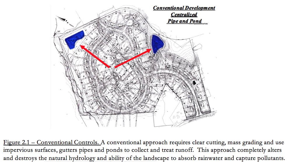
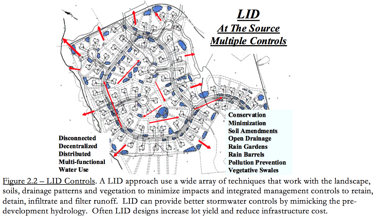
LID uses new management principles such as conservation of soils and drainage patterns; using integrated decentralized controls; uniform distribution of lot-level controls to increase runoff storage, contact time and time of travel; and, multifunction landscape features engineered to make the most cost effective use of space. The landscape is comprehensively engineered and optimized for stormwater controls. All of these principles are in direct contrast to conventional end-of-pipe treatment. Figure 2.1 and Figure 2.2 contrasts conventional centralized controls with a LID decentralized approach.
To optimize the benefits of LID, there is also a specific site planning and design process to follow. This process includes optimizing conservation at the larger project level; minimize impacts at site level, maintaining drainage features and use of engineered integrated management practices. The principles and design processes are explained in more detail below.
2.1 Basic Planning Principles
A well-designed integrated stormwater management system will minimize the volume of runoff generated and maximize the treatment capabilities of the landscape. A LID design controls runoff as close to the source as possible. A well-designed system should also be easy to maintain, not interfere with the typical use of the property, and be aesthetically pleasing. To optimize a LID design, it is important to consider a number of site planning principles and follow a systematic design processes from the very beginning. Each site has a unique set of characteristics and will require the use of a unique blend of site specific LID planning and treatment techniques. In considering the advantages and constraints of each site, four fundamental concepts should remain preeminent:
1. Minimizing site disturbance
Undisturbed lands possess a natural capacity to store runoff waters. Development sites may include areas that are relatively sensitive to impact from construction (e.g., erosion) or may encompass particularly rare or valuable environmental features. Protecting susceptible natural features provides the multiple benefits of preserving important resources, reducing development impact and providing capacity for prevention of erosion.
Generally, developers should inventory and map natural features such as surface waters, vegetated wetlands and highly erodible soils, for preservation early in the site planning process. This helps to define a practicable development envelope. Preserved areas must be protected throughout construction and demarcated for conservation in land records.
2. Working with site hydrology
Traditional erosion prevention seeks to eliminate the annoyance and hazard of runoff by rapidly conveying it away from development—typically, via closed drainage systems such as storm sewers. This approach works efficiently to remove water from streets and sidewalks, but it expends significant capital for constructed systems that interrupt the recharge of groundwater resources. By contrast, LID techniques work to reduce stormwater generation or retain it in the upland where it can percolate naturally into the soil and replenish groundwater resources.
3. Minimizing and disconnecting impervious surface
Runoff comes primarily from impervious surface, such rooftops, roadways or any smooth hard surface that prevents water from absorbing into the ground. Traditional developments tend to include superfluous impervious surface, which may be minimized with thoughtful site planning. Techniques to limit impervious area include reducing road widths and lengths as well as the area of rooftops (e.g., preference for multi-story over single-story buildings).
To the extent possible, developers should promote contact between runoff and pervious land surface. Technically, this is done by increasing time of concentration—length of time required for runoff to concentrate and flow off site—and by reducing the runoff curve number.
4. Applying small-scale controls at the source
Small-scale practices applied at the source—or as close as practicable—can offer significant advantages over conventional, engineered facilities such as ponds or concrete conveyances. They can decrease the use of typical engineering materials such as steel and concrete. By using materials such as native plants, soil and gravel these systems can be more easily integrated into the landscape and appear to be much more natural than engineered systems. The natural characteristics may also increase homeowner acceptance and willingness to adopt and maintain such systems. Small, distributed systems also offer a major technical advantage—one or more of the systems can fail without undermining the overall integrity of the site control strategy.
Small-scale practices reduce safety concerns as they feature shallow basin depths and gentle side slopes. The integration of these facilities into the landscape throughout the site offers more opportunities to mimic the natural hydrologic functions and add aesthetic value. The adoption of these landscape features by the general public and individual property owners can result in significant maintenance and upkeep savings to the homeowners association, municipality or other management entity.
Another important factor in LID design is that it is best applied by a multidisciplinary team of professionals. The contributions of soils scientist, biologist, landscape architects, urban planners, and engineers are all equally important. It is not just about meeting the volume storage and flow regulatory requirements, it is about professionals using their combined knowledge and skills to create and design the most ecologically functional, economically viable, aesthetically pleasing livable community possible.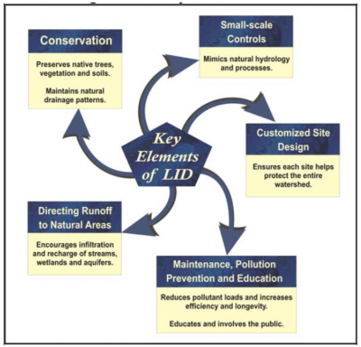
Several basic LID planning principles should remain in the forefront throughout the various steps of the site planning and design process. These principles require a completely different way of thinking about site design than current convention.
For example, an important LID concept is to keep water on the site as long as possible using the landscape to treat runoff, but without causing flooding problems or interfering with the typical use of the property.
This is in contrast to the current practice of grading a site to quickly move water away from buildings and roadways. Until LID designs become the normal way of doing business a good design will require more time and creativity to manage runoff within the landscape effectively.
Basic LID principles include:
-
- Optimize conservation – Save natural resource areas, vegetation and soils and wisely use them to reduce and treat runoff to maintain the site’s ability to retain and detain runoff.
- Mimic the natural water balance – To the extent possible continue to store detain and infiltrate water in the manner and rate as predevelopment. This requires careful evaluation of site soils in order to save sandy soils and use these areas as part of the LID control strategy. Conserving natural drainage features and topography will help to maintain the natural frequency of discharges.
- Disconnect Impervious Surfaces – Always disconnect impervious surfaces. The site’s runoff characteristics are completely changed when impervious surfaces drain to landscape features or engineered LID practices. This approach prevents the adverse cumulative effects of collecting and concentrating flows and helps to reduce erosion problems.
- Decentralize and Distribute Controls – The more LID techniques used and the more uniformly distributed throughout the landscape the more effective LID becomes. Increasing runoff time of travel significantly reduces flows and discharge frequencies. Increasing storage features decreases runoff volume and reduces annual pollutant loads. Utilizing all landscape features for filtration increases its capacity to capture and cycle pollutants.
- Multifunctional/Multipurpose Landscapes – Every aspect of the urban landscape can be design to either reduce or restore hydrologic functions. Every landscape feature should be optimized to provide beneficial hydrologic and water quality functions by preventing, storing, retaining, detaining, and treating runoff.
- Cumulative Impacts of Multiple Systems – LID relies on cumulative beneficial impacts of an array of LID planning and design principles and various treatment practices. As more LID techniques are used to store or detain runoff, the developed site also more closely replicates the natural hydrologic regime. One interesting aspect of LID--because so many techniques are used, failure of a few practices does not significantly compromise management objectives. Contrast this with using one large stormwater pond—if that one big pond fails, the entire system fails.
- Prevention, Outreach and Education – All efforts should be made to reduce the introduction of pollutants into the environment. Therefore, a good LID program or project also includes effective public education and outreach to help ensure proper use, handling, disposal of pollutants, and maintenance of LID practices.
The first three of these principles lend themselves to development of specific design standards and are used in Section 4 of this guidance to organized LID practices.
2.2.3 Step 3 – Optimize Conservation of Natural Features at the Larger Watershed Scale
LID does not promote the use of any particular style site development such as traditional neighborhood design, conventional grid patterns, cluster development, conservation design or new urbanism. Regardless of the development style, LID techniques can always be used throughout the site. The examples to the right (Figure 2.4) demonstrate integration of resource conservation into a conventional design. Natural features are saved to reduce impacts and allow for greater use of natural features to treat runoff. Conserving natural features not only reduces impacts but preserves habitat and natural ecological processes to be used for stormwater controls.
The most successful LID design begins with understanding of the site’s natural resources and how best to save these features and incorporate them into the stormwater management system. To the extent practicable and in accordance with current regulations, natural features (wetlands, trees/vegetation, good soils) should be conserved and integrated into the overall site plan. The conservation features should continue to be used by directing runoff to the natural features in the same manner as the predevelopment conditions. The greater use of natural features generally means reduction of clearing and grading and lower cost.
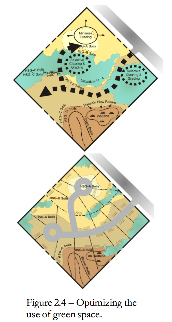
Locating infrastructure to direct runoff to buffers, vegetative filters, existing drainage features will help to reduce runoff quantity and improve water quality. This approach reduces disturbance of the natural soils and vegetation allowing more areas for infiltration and runoff contact with the landscape. To optimize the use of green space requires an ability to lay out the site infrastructure in a way that allows saving sensitive the natural features and their functions. The basic strategy is shown in Figure 2.4.
There are many techniques that should be considered including:
- Minimizing and properly stage grading and clearing for roadways and building pads as only necessary.
- Locating, saving and utilizing pervious soils.
- Locating treatment practices in pervious hydrologic soil groups A and B.
- Where feasible, constructing impervious surfaces on less pervious hydrologic soils groups C and D.
- Disconnecting impervious surfaces by draining them to natural features.
- Flattening slopes where possible.
- Re-vegetating cleared and graded areas.
- Utilizing existing drainage patterns.
- Routing flow over longer distances.
- Using overland sheet flow.
- Maximizing runoff storage in natural depressions.
2.2.4 Step 4 – Minimize Impacts at the Lot Level
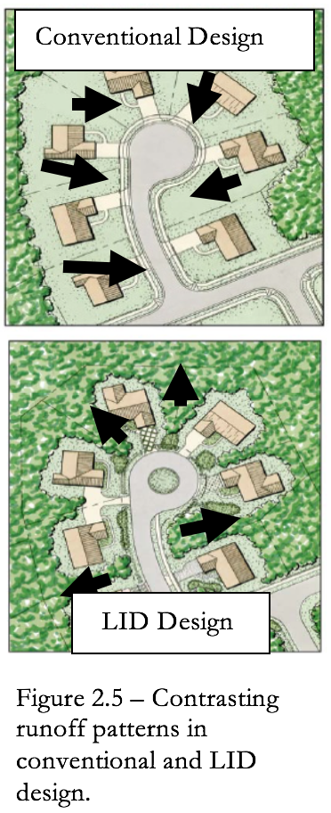
To the extent practicable, conserve trees, natural drainage patterns, pervious soils and depressions at the lot level. This often means less clearing and grading. Figure 2.5 contrasts the conventional approach of draining runoff to the streets vs. a LID design using site fingerprinting where runoff is directed to the natural features.
The key to preventing excessive runoff from being generated is slow down velocities by directing it toward areas where it can be absorbed. The reliance on many small measures used throughout the site will serve this purpose better than a single large control measure.
There are many lot level techniques that should be considered including: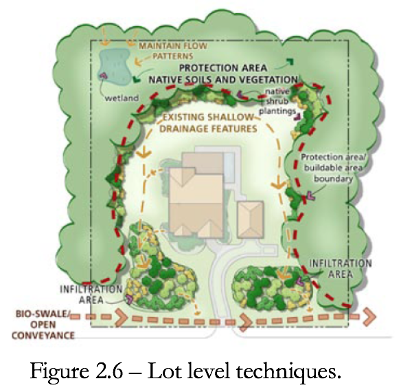
- Avoiding installation of roof drains.
- Directing flows to vegetated areas.
- Directing flows from paved areas to stabilized vegetated areas.
- Breaking up flow directions from large paved surfaces.
- Encouraging sheet flow through vegetated areas.
- Locating impervious areas so that they drain to permeable areas.
- Maximizing overland sheet flow.
- Lengthening flow paths and increase the number of flow paths.
- Maximizing use of open swale systems.
- Increasing (or augmenting) the amount of vegetation on the site.
- Using site fingerprinting. Restricting ground disturbance to the smallest possible area.
- Reducing paving.
- Reducing compaction or disturbance of highly permeable soils.
- Avoiding removal of existing trees.
- Reducing the use of turf and use more natural land cover.
- Maintaining existing topography and drainage divides.
- Locating structures, roadways on Type C soils where feasible.[1]
Various lot level techniques are illustrated in Figure 2.6.
[1] Because Type C and D soils tend to be poorly suited to construction, site structures on them may be ineffective from a cost-benefit standpoint or technically impractical.