Chapter 7: Hydrologic Sizing Criteria for Stormwater Treatment Practices (2004)

7.1 Introduction

This chapter presents a recommended approach for sizing stormwater treatment practices in the State of Connecticut. Although the primary focus of this manual is on stormwater quality, the management of stormwater quantity is an important related concern.  Therefore, the sizing criteria in this chapter are designed to achieve both water quality and quantity control objectives. The recommended sizing criteria have been adapted from the Center for Watershed Protection’s Unified Sizing Criteria, which is one of the more comprehensive approaches for sizing stormwater treatment practices developed to date.  This approach has been implemented in several other states including Maryland, New York, Vermont, and Georgia.


The sizing approach described in this chapter is intended to manage the full spectrum of storm flows and their associated water quality and quantity impacts.  These range from small, frequent storms that are responsible for a majority of the annual runoff volume and pollutant loads to large, infrequent events which are responsible for nuisance and catastrophic flooding.   Stormwater treatment practices should be designed to accomplish the following primary objectives:


  • Pollutant reduction
  • Runoff volume reduction and groundwater recharge
  • Stream channel protection and peak flow control.


The following sections of this chapter describe criteria and methods for sizing stormwater treatment practices to meet these objectives.  These criteria are intended to be consistent with local subdivision and planning/zoning ordinances of most municipalities throughout the state, particularly regarding peak flow control requirements.  Some differences may exist between the criteria presented in this chapter and local requirements. Local requirements should be consulted in addition to these criteria. However, the criteria presented in this chapter are recommended where local regulations are less stringent.

7.2 Criteria Applicability

The design criteria presented in this chapter are generally applicable to the following types of new development and redevelopment projects, including phased developments:


  • Any development resulting in the disturbance of greater than or equal to one acre of land
  • Residential development consisting of 5 or more dwelling units
  • Residential development consisting of <5 dwelling units involving construction of a new road or reconstruction of an existing road
  • Residential development consisting of <5 dwelling units where imperviousness of the site after construction exceeds 30%
  • Stormwater discharge to sensitive wetlands/watercourses
  • New stormwater discharges located less than 500 feet from tidal wetlands
  • Land uses or activities with potential for higher pollutant loadings (see Table 7-5), excluding the groundwater recharge criterion
  • Industrial and commercial development projects which result in 10,000 sq. ft. or greater of impervious surface
  • New highway, road, and street construction
  • Modifications to existing storm drainage systems.


These and other types of projects not listed above, such as single family residential development, are encouraged to incorporate alternative site design, low impact development practices, and source controls to reduce imperviousness, runoff volumes, and stormwater pollutant sources.


Some of the sizing criteria presented in this chapter may not be practical to meet due to space limitations, soil conditions, and other site constraints which are common in redevelopment or retrofit applications.  Treatment practices sized for smaller treatment volumes/flows or exemptions from certain criteria may be appropriate in these situations, at the discretion of the review authority. Conditions where the recommended sizing criteria may not be applicable are identified in the following sections.

7.3 Criteria Summary

Table 7-1 summarizes the hydrologic sizing criteria for stormwater treatment practices in Connecticut.  As indicated in Table 7-1, the sizing criteria are based on stormwater runoff generated by 24-hour duration storms of various return frequencies (i.e., design storms).  Table 7-2 lists 24-hour design rainfall depths for each county in Connecticut.  The rationale for and application of these criteria are described in the following sections.


Table 7‑1. Summary of Stormwater Treatment Practice Sizing Criteria

Sizing Criteria

Description

Post-Development

Storm Magnitude

Pollutant Reduction


Water Quality Volume (WQV)

Volume of runoff generated by one inch of rainfall on the site


WQV = (1”)(R)(A)/12


WQV = water quality volume (ac-ft)

R = volumetric runoff coefficient = 0.05+0.009(I)

I =  percent impervious cover

A = site area in acres


Water Quality Flow (WQF)

Peak flow associated with the water quality volume calculated using the NRCS Graphical Peak Discharge Method


First one inch of rainfall


Groundwater Recharge and Runoff Volume Reduction


Groundwater Recharge Volume (GRV)

Maintain pre-development annual groundwater recharge volume to the maximum extent practicable through the use of infiltration measures


Runoff Capture Volume (RCV)

Retain on-site the volume of runoff generated by one inch of rainfall for new stormwater discharges located within 500 feet of tidal wetlands


RCV = (1”)(R)(A)/12


RCV = runoff capture volume (ac-ft)

R = volumetric runoff coefficient = 0.05+0.009(I)

A = site area in acres


Not applicable


First one inch of rainfall


Peak Flow Control


Stream Channel Protection

Control the 2-yr, 24-hour post-development peak flow rate to 50 percent of the 2-yr, 24-hr pre-development level or to the 1-yr, 24-hr pre-development level (“Two-Year Over-Control”).


Conveyance Protection

Design the conveyance system leading to, from, and through stormwater management facilities based on the 10-year, 24-hour storm.


Peak Runoff Attenuation

Control the post-development peak discharge rates from the 10-, 25-, and 100-year storms to the corresponding pre-development peak discharge rates, as required by the local review authority.


Emergency Outlet Sizing

Size the emergency outlet to safely pass the post-development peak runoff from, at a minimum, the 100-year storm in a controlled manner without eroding the outlet works and downstream drainages.


2-year, 24-hour rainfall


10-year, 24-hour rainfall


10-, 25-, and 100-year 24-hour rainfall


100-year, 24-hour rainfall


Consult local regulations for additional criteria.  The above criteria are recommended where local regulations are less stringent.


Table 7‑2. Design Rainfall Amounts By County

  24-Hour Rainfall Amount (inches)
County 1-yr 2-yr 10-yr 25-yr 100-yr
Fairfield 2.7 3.3 5.0 5.7 7.2
Hartford 2.6 3.2 4.7 5.5 6.9
Litchfield 2.6 3.2 4.7 5.5 7.0
Middlesex 2.7 3.3 5.0 5.6 7.1
New Haven 2.7 3.3 5.0 5.6 7.1
New London 2.7 3.4 5.0 5.7 7.1
Tolland 2.6 3.2 4.8 5.5 6.9
Windham 2.6 3.2 4.8 5.5 6.9

Source: TP-40, Department of Commerce, Weather Bureau, May 1961; NWS Hydro-35, Department of Commerce, National Weather Service, June 1977.

7.4 Pollutant Reduction

The pollutant reduction criterion is designed to improve the water quality of stormwater discharges by treating a prescribed water quality volume or associated peak flow, referred to as the water quality flow.  Most treatment practices described in this manual use a volume-based sizing criterion.  The exceptions are grass drainage channels, proprietary stormwater treatment devices, and flow diversion structures, where a peak flow rate is utilized.

7.4.1 Water Quality Volume (WQV)

Description

The water quality volume (WQV) is the amount of stormwater runoff from any given storm that should be captured and treated in order to remove a majority of stormwater pollutants on an average annual basis.  The recommended WQV, which results in the capture and treatment of the entire runoff volume for 90 percent of the average annual storm events, is equivalent to the runoff associated with the first one-inch of rainfall.  The WQV is calculated using the following equation:

Water Quality Volume is equal to one inch multiplied by the volumetric runoff coefficient multiplied by the site area in acres. All over 12.

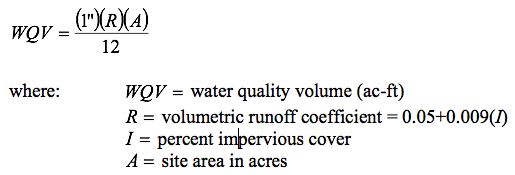
  • The volumetric runoff coefficient R can also be determined from commonly available tabulated values for various land use, vegetative cover, soil, and ground slope conditions. However, the use of the above equation is recommended since it is directly related to the amount of impervious cover at a site, thereby providing incentive to reduce site imperviousness and the required runoff treatment volume.  Reducing impervious cover using the site planning and design techniques described in Chapter Four can significantly reduce the WQV.


  • Impervious cover should be measured from the site plan and includes all impermeable surfaces that are directly connected to the stormwater treatment practice such as paved and gravel roads, rooftops, driveways, parking lots, sidewalks, pools, patios and decks. In the absence of site-specific information or for large residential developments, impervious cover may be estimated based on average impervious coverage values for various parcel sizes listed in Table 7-3.  The values shown in Table 7-3 were derived from research by the University of Connecticut, Cooperative Extension System NEMO Project (Prisloe et al., no date).


Table 7‑3. Residential Land Use Impervious Cover

Parcel Size (acres) Average Percent Impervious Cover
<1/8 39
1/8 to ¼ 28
¼ to ½ 21
½ to ¾ 16
¾ to 1 14
1 to 1½ 10
1½ to 2 9
>2 8


  • The WQV should be treated by an acceptable stormwater treatment practice or group of practices described in this manual. The WQV should be used for the design of the stormwater treatment practices described in this manual, except grass drainage channels and proprietary stormwater treatment devices (e.g., hydrodynamic separators, catch basin inserts, and media filters), which should be designed based on the water quality flow (WQF).


Rationale

The above approach is similar to water quality sizing criteria that have been adopted elsewhere in the United States for the design of stormwater treatment practices.  These criteria are intended to remove the majority of pollutants in stormwater runoff at a reasonable cost by capturing and treating runoff from small, frequent storm events that account for a majority of the annual pollutant load, while bypassing larger, infrequent storm events that account for a small percentage of the annual pollutant load.  This approach is based on the “first flush” concept, which assumes that the majority of pollutants in urban stormwater runoff are contained in the first half-inch to one-inch of runoff primarily due to pollutant washoff during the first portion of a storm event. Early studies in Florida determined that the first flush generally carries 90 percent of the pollution from a storm (Novotny, 1995).  As a result, treatment of the first half-inch of runoff was adopted as a water quality volume sizing criterion requirement throughout much of the United States. More recent research has shown that pollutant removal achieved using the half-inch rule drops off considerably as site imperviousness increases.


A number of alternative water quality sizing methods were developed to achieve higher pollutant removals for a wider range of site imperviousness.  One of the more common methods is known as the “90 Percent Rule”, in which the water quality volume is equal to the storage required to capture and treat 90 percent of the annual runoff events (approximately 90% of the annual runoff pollutant load) based on analysis of historical precipitation records.  The specific rainfall event captured is the storm event that is less than or equal to 90 percent of all 24-hour storms on an average annual basis.  In the northeastern U.S., the 90 percent rainfall event is equal to approximately one inch, which is consistent with the recommended WQV sizing criteria for Connecticut.

7.4.2 Water Quality Flow (WQF)

Description

The water quality flow (WQF) is the peak flow rate associated with the water quality design storm or WQV.  Although most of the stormwater treatment practices in this manual should be sized based on WQV, some treatment practices such as grass drainage channels and proprietary treatment devices (designed to treat higher flow rates, thereby requiring less water quality storage volume) are more appropriately designed based on peak flow rate.  In this approach, a stormwater treatment facility must have a flow rate capacity equal to or greater than the WQF in order to treat the entire water quality volume (Adams, 1998).  In addition, flow diversion structures for off-line stormwater treatment practices can also be designed to bypass flows greater than the WQF.


The WQF should be calculated using the WQV described above and the NRCS, TR-55 Graphical Peak Discharge Method.  The procedure is based on the approach described in Claytor and Schueler, 1996 and is summarized in Appendix B. Appendix B also contains design guidance for flow diversion structures.


Rationale

The use of the NRCS, TR-55 Graphical Peak Discharge Method in conjunction with the water quality volume for computing the peak flow associated with the water quality design storm is preferable to both traditional SCS Methods and the Rational Equation, both of which have been widely used for peak runoff calculations and drainage design.  The traditional SCS TR-55 methods are valuable for estimating peak discharge rates for large storms (i.e., greater than 2 inches), but can significantly underestimate runoff from small storm events (Claytor and Schueler, 1996).  Similarly, the Rational Equation may be appropriate for estimating peak flows for small urbanized drainage areas with short times of concentration, but does not estimate runoff volume and is based on many restrictive assumptions regarding the intensity, duration, and aerial coverage of precipitation.  The Rational Equation is highly sensitive to the time of concentration and rainfall intensity, and therefore should only be used with reliable intensity, duration, frequency (IDF) tables or curves for the storm and region of interest (Claytor and Schueler, 1996).

7.5 Groundwater Recharge and Runoff Volume Reduction

This criterion is designed to reduce stormwater runoff volumes and maintain groundwater recharge rates to pre-development levels.  The criterion includes two components – groundwater recharge and runoff capture, which are described below.

7.5.1 Groundwater Recharge Volume (GRV)

Description

The groundwater recharge criterion is intended to maintain pre-development annual groundwater recharge volumes by capturing and infiltrating stormwater runoff. The objective of the groundwater recharge criterion is to maintain water table levels, stream baseflow, and wetland moisture levels.  Maintaining pre-development groundwater recharge conditions can also reduce the volume requirements dictated by the other sizing criteria (i.e., water quality, channel protection, and peak flow control) and the overall size and cost of stormwater treatment practices.


The groundwater recharge volume (GRV) is the post-development design recharge volume (i.e., on a storm event basis) required to minimize the loss of annual pre-development groundwater recharge.  The GRV is determined as a function of annual pre-development recharge for site-specific soils or surficial materials, average annual rainfall volume, and amount of impervious cover on a site. Several approaches can be used to calculate the GRV:


  • Hydrologic Soil Group Approach: This method was first developed and adopted by the state of Massachusetts, and has since been implemented in several other states including Maryland and Vermont. This approach involves determining the average annual predevelopment recharge volume at a site based on the existing site hydrologic soil groups (HSG) as defined by the United States Natural Resources Conservation Service (NRCS) County Soil Surveys (MADEP, 1997). Based on this approach, the GRV can be calculated as the depth of runoff to be recharged, multiplied by the area of impervious cover, as shown below:

Groundwater recharge volume (ac-ft), is equal to the depth of runoff to be recharged (inches) multiplied by site area (acres) multiplied by site imperiousness. All over 12.


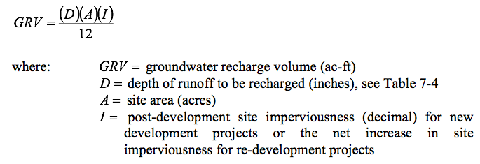
Table 7‑4. Groundwater Recharge Depth


NRCS Hydrologic

Soil Group


Average Annual Recharge


Groundwater Recharge Depth (D)


A 18 inches/year 0.4 inches
B 12 inches/year 0.25 inches
C 6 inches/year 0.10 inches
D 3 inches/year 0 inches (waived)

Source: MADEP, 1997.

NRCS – Natural Resources Conservation Service


Where more than one hydrologic soil group is present on a site, a composite or weighted recharge value should be calculated based upon the relative area of each soil group. The GRV should be infiltrated in the most permeable soil group available on the site.


  • USGS Surficial Materials Approach: This approach is similar to the above hydrologic soil group method, except the pre-development average annual recharge quantities and recharge depths are based on the predominant surficial materials classifications on the site (coarse-grained stratified drift versus glacial till and bedrock) as determined from U.S. Geological Survey (USGS) mapping. In areas underlain by coarse-grained stratified drift, average annual recharge is approximately three times greater than from till and bedrock areas. Areas of coarse-grained stratified drift and till/bedrock can be obtained from USGS 7.5-minute topographic maps of 1:24,000 scale, available from the USGS and DEP. Estimates of average annual recharge values for these materials are available from the Connecticut Water Resources Inventory Bulletins prepared jointly by the USGS and DEP for the major drainage basins throughout the state.


  • Other Methods: Predevelopment recharge values and the required GRV can also be determined using the results of on-site soil evaluations or other geologic information provided that information sources and methods are clearly documented.


Meeting the recharge requirement can be accomplished through the use of primary treatment practices (infiltration, bioretention, filtration, and swales), secondary treatment practices (drywells, permeable pavement, level spreaders), and non-structural site design techniques such as disconnection of rooftop runoff and grading. Stormwater ponds, wetlands, and sediment forebays generally are not suitable for groundwater recharge since they are either designed with impermeable bottoms or have significantly reduced permeability due to accumulation of fine sediment.  When designing infiltration practices, a factor of safety should be used to account for potential compaction of soils by construction equipment, which can significantly reduce soil infiltration capacity and groundwater recharge. See the design sections of this manual for guidance on the design and construction of infiltration practices to reduce this potential.


The GRV is considered as part of the total water quality volume (WQV) and therefore can be subtracted from the WQV, provided that the proposed infiltration measures are capable of infiltrating the required recharge volume. Reducing the WQV (and consequently the size and cost of stormwater treatment) is an additional incentive for meeting the groundwater recharge criterion.  Additionally, both WQV and GRV are a function of site imperviousness, providing further incentive to minimize site impervious cover.


There are several instances where the groundwater recharge criterion should be waived to protect against contamination of drinking water supplies and mobilization of existing subsurface contamination.  Infiltration of stormwater is not recommended under the following site conditions:


  • Land Uses or Activities with Potential for Higher Pollutant Loads: Infiltration of stormwater from these land uses or activities (Table 7-5), also referred to as stormwater “hotspots,” can contaminate public and private groundwater supplies. Infiltration of stormwater from these land uses or activities may be allowed by the review authority with appropriate pretreatment. Pretreatment could consist of one or a combination of the primary or secondary treatment practices described in this manual provided that the treatment practice is designed to remove the stormwater contaminants of concern.


  • Subsurface Contamination: Infiltration of stormwater in areas with soil or groundwater contamination such as brownfield sites and urban redevelopment areas can mobilize contaminants.


  • Groundwater Supply Areas: Infiltration of stormwater can potentially contaminate groundwater drinking water supplies in public drinking water aquifer recharge areas and wellhead protection areas.


Table 7‑5. Land Uses or Activities with Potential for Higher Pollutant Loads

Land Use/Activities


·       Industrial facilities subject to the DEP Industrial Stormwater General Permit or the U.S. EPA National Pollution Discharge Elimination System (NPDES) Stormwater Permit Program1

·       Vehicle salvage yards and recycling facilities

·       Vehicle fueling facilities (gas stations and other facilities with on-site vehicle fueling)

·       Vehicle service, maintenance, and equipment cleaning facilities

·       Fleet storage areas (cars, buses, trucks, public works)

·       Commercial parking lots with high intensity use (shopping malls, fast food restaurants, convenience stores, supermarkets, etc.)

·       Public works storage areas

·       Road salt storage facilities (if exposed to rainfall)

·       Commercial nurseries

·       Flat metal rooftops of industrial facilities

·       Facilities with outdoor storage and loading/unloading of hazardous substances or materials, regardless of the primary land use of the facility or development

·       Facilities subject to chemical inventory reporting under Section 312 of the Superfund Amendments and Reauthorization Act of 1986 (SARA), if materials or containers are exposed to rainfall

·       Marinas (service and maintenance)

·       Other land uses and activities as designated by the review authority

1Stormwater pollution prevention plans are required for these facilities.  Pollution prevention and source controls are recommended for the other land uses and activities listed above.


Rationale

The objective of the groundwater recharge criterion is to mimic the average annual recharge rate for pre-development site conditions.  The recommended approach for calculating the GRV (i.e., the required stormwater infiltration volume) is a function of post-development site imperviousness and the prevailing surface permeability and infiltration capacity. The hydrologic soil group approach uses the widely available NRCS Soil Survey maps and estimates of average annual infiltration rates for each hydrologic soil group. This method has been adopted in Massachusetts and other northeastern states, which have humid climates and receive approximately 44 inches of average annual rainfall. The recharge factors developed for this approach are also valid for Connecticut, which has similar rainfall, soils, and climate.


The alternative surficial materials approach may be less accurate than other soil-specific methods for estimating site-specific infiltration rates. The annual recharge values for surficial material categories are based on basin-wide analyses of stratified drift and till, which may not be applicable to specific sites. However, the approach is believed to be suitable for estimating the required recharge volume and utilizes readily available, published information from the USGS and DEP.


Massachusetts is in the process of revising their groundwater recharge guidance, including review and potential modification of the groundwater recharge factors. Future revisions of this manual will incorporate refinements to this and other groundwater recharge methods as they become available to promote consistent and widespread application of infiltration measures.

7.5.2 Runoff Capture Volume (RCV)

Description

The objective of the runoff capture criterion is to capture stormwater runoff to prevent the discharge of pollutants, including “unpolluted” fresh water, to sensitive coastal receiving waters and wetlands.  The runoff capture criterion applies to new stormwater discharges located less than 500 feet from tidal wetlands, which are not fresh-tidal wetlands.  The stormwater runoff volume generated by the first inch of rainfall must be retained on-site for such discharges.  The runoff capture volume is equivalent to the WQV and can be calculated using the following equation:

Runoff capture volume (acre-feet) is equal to 1 inch multiplied by the volumetric runoff coefficient, multiplied by the site area (acres), all over 12


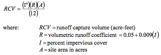
Wet ponds designed with adequate storage volume to capture and retain the RCV or infiltration practices described in this manual can be used to satisfy the runoff capture volume criterion.


Rationale

The runoff capture volume criterion is consistent with DEP coastal management policy and stormwater general permit requirements.  Discharge of the “first-flush” of stormwater runoff into brackish and tidal wetlands is prohibited due to the resultant dilution of the high marsh salinity and encouragement of the invasion of brackish or upland wetland species such as Phragmites.

7.6 Peak Flow Control

Peak flow control criteria are intended to address increases in the frequency and magnitude of a range of potential flood conditions resulting from development. These include relatively frequent events that cause channel erosion, larger events that result in bank full and overbank flooding, and extreme floods. The following sections describe sizing criteria for controlling peak flows, as well as for designing stormwater conveyance and emergency outlet structures. Natural Resource Conservation Service (NRCS) peak flow calculation methods such as TR-55 or TR-20 should be used to compute the required peak flow rates for each of the criteria described below.

7.6.1 Stream Channel Protection

Description

The stream channel protection criterion is intended to protect stream channels from erosion and associated sedimentation in downstream receiving waters and wetlands as a result of urbanization within a watershed. By restricting peak flows from storm events that result in bank full flow conditions (typically the 2-year storm, which controls the form of the stream channel), damaging effects to the channel from increased runoff due to urbanization can be reduced.

Either of the following two methods can be used to satisfy the stream channel protection criterion. Both rely on “over-control” of the two-year frequency design storm.

• Control the 2-year, 24-hour post-development peak flow rate to 50 percent of the 2-year, 24-hour pre-development level, or

• Control the 2-year, 24-hour post-development peak flow rate to the 1-year, 24-hour pre-development level.

There are several practical limitations on the application of the stream channel protection criterion. For sites having less than one acre of impervious cover, the size of the orifice or weir required for extended detention becomes too small (approximately 1 inch in diameter) to effectively operate without clogging. In addition, channel protection is generally not required where sites discharge to a large receiving water body (Brown and Caraco, 2001). Therefore, the channel protection criterion does not apply under the following conditions:

• The entire channel protection volume is recharged to groundwater
• For sites less than or equal to one acre of impervious cover
• The site discharges to a large river (fourth order or greater), lake, estuary, or tidal water where the development area is less than 5% of the watershed area upstream of the development site unless known water quality problems exist in the receiving waters. Stream order indicates the relative size of a stream based on Strahler’s (1957) method. Streams with no tributaries are first order streams, represented as the start of a solid line on a 1:24,000 USGS Quadrangle Sheet. A second order stream is formed at the confluence of two first order streams, and so on.

Rationale

A number of design criteria have been developed for the purpose of stream channel protection. The earliest and most common method relied on control of post-development peak flows associated with the 2-year, 24-hour storm event to pre-development levels based on the assumption that bankfull discharge for most streams has a recurrence interval of between 1 and 2 years (Leopold, et al., 1964 and Leopold, 1994). More recent research indicates that this method does not adequately protect stream channels from downstream erosion and may actually contribute to erosion since banks are exposed to a longer duration of erosive bank full and sub-bankfull events (MacRae, 1993 and 1996, McCuen and Moglen, 1988).

The two-year “over-control” methods recommended above were developed as a modification of the original two-year control approach to provide additional protection. These methods require larger detention volumes than the traditional two-year approach, but reduce the duration of bank full flows. More recent research has shown that extended detention of the 1-year, 24-hour storm event and a method referred to as Distributed Runoff Control (DRC) potentially provide the highest level of stream channel protection. In the extended detention method, the runoff volume generated by the 1-year, 24-hour rainfall (2.6 to 2.7 inches in Connecticut) is captured and gradually released over a 24-hour period to control erosive velocities in downstream channels. However, this method results in extremely large detention storage requirements (comparable to the storage volume required for 10-year peak discharge control), and the incremental benefits of this approach over the two-year over-control approach are undocumented. The DRC method involves detailed field assessments and hydraulic/hydrologic modeling to determine hydraulic stress and erosion potential of streambanks. This level of detailed, site-specific analysis is not warranted for use as a general stream channel protection criterion.

7.6.2 Conveyance Protection

Description

The conveyance systems to, from, and through stormwater management facilities should be designed based on the peak discharge rate for the 10-year, 24-hour storm.  This criterion is designed to prevent erosive flows within internal and external conveyance systems associated with stormwater treatment practices such as channels, ditches, berms, overflow channels, and outfalls. The local review authority may require the use of larger magnitude design storms for conveyance systems associated with stormwater treatment practices.


Rationale

This criterion is generally consistent with storm drainage system design in Connecticut, including design requirements of most municipalities and the Connecticut Department of Transportation.

7.6.3 Peak Runoff Attenuation

Description

The peak runoff attenuation criterion is designed to address increases in the frequency and magnitude of flooding caused by development.  This criterion is intended to control a range of flood conditions, from events that just exceed the bank full capacity of the stream channel to catastrophic flooding associated with extremely large events.  Other objectives include maintaining the boundaries of the pre-development 100-year floodplain and protecting the physical integrity of stormwater management facilities.


The recommended peak runoff attenuation criterion in Connecticut includes control of post-development peak discharge rates from the 10-year, 25-year, and 100-year storms to the corresponding pre-development peak discharge rates, as required by the local review authority. The local review authority may require peak runoff attenuation for additional design storms such as the 1-year, 2-year, 5-year and 50-year, 24-hour events.  The local review authority may waive the peak runoff attenuation criterion for sites that discharge to a large river (fourth order or greater), lake, estuary, or tidal waters where the development area is less than 5% of the watershed area upstream of the development site.


Rationale

This criterion is generally consistent with storm drainage system design in Connecticut, including design requirements of most municipalities and the Connecticut Department of Transportation.

7.6.4 Emergency Outlet Sizing

Description

The emergency outlets of stormwater management facilities should be designed to safely pass the peak discharge rate associated with the 100-year storm or larger.  The emergency outlet should be able to pass the 100-year peak runoff rate, at a minimum, in a controlled manner, without eroding outfalls or downstream conveyances. Emergency outlets constructed in natural ground are generally preferable to constructed embankments. This criterion is applicable to all stormwater management facilities that employ an emergency outlet.


Rationale

This criterion is generally consistent with storm drainage system design in Connecticut, including design requirements of most municipalities and the Connecticut Department of Transportation.

7.6.5 Downstream Analysis

Peak runoff control criteria are typically applied at the immediate downstream boundary of a project area.  However, since stormwater management facilities may change the timing of the post-development hydrograph, multiple stormwater treatment practices or detention facilities in a watershed may result in unexpected increases in peak flows at critical downstream locations such as road culverts and areas prone to flooding.  This effect is most pronounced for detention structures in the middle to lower third of a watershed.  The local review authority may require a downstream analysis to identify potential detrimental effects of proposed stormwater treatment practices and detention facilities on downstream areas.


The downstream analysis should include the following elements:


  • Routing calculations should proceed downstream to a confluence point where the site drainage area represents 10 percent of the total drainage area (i.e., the “10 percent rule”).


  • Calculation of peak flows, velocities, and hydraulic effects at critical downstream locations (stream confluences, culverts, other channel constrictions, and flood-prone areas) to the confluence point where the 10 percent rule applies.


  • The analysis should use an appropriate hydrograph routing method, such as TR-20, to route the pre- and post-development runoff hydrographs from the project site to the downstream critical locations.

The ultimate objective of this analysis is to ensure that proposed projects do not increase post-development peak flows and velocities at critical downstream locations in the watershed.  Increases in flow rates and velocities at these locations should be limited to less than 5 percent of the pre-developed condition (NYDEC, 2001) and should not exceed freeboard clearances or allowable velocities.

7.7 Sizing Example

The following example illustrates how the various sizing criteria described in this chapter are applied to determine stormwater treatment requirements (required storage volume and hydraulic capacity) for a hypothetical development project.


Old Town Office Building, New London, Connecticut


An office building is proposed on a commercial property in New London, Connecticut. The approximately 2-acre site is characterized by Type B soils. The proposed development consists of approximately 80 percent impervious area (parking lots and buildings), with approximately 20 percent as lawn or undisturbed area. Runoff from the impervious areas is collected and conveyed to a hypothetical stormwater treatment basin located on the southwest portion of the site. Stormwater is discharged from the basin to an adjacent tidal wetland. Figure 7-1 shows a schematic layout of the proposed development.Proposed Old Town Office building and project data.


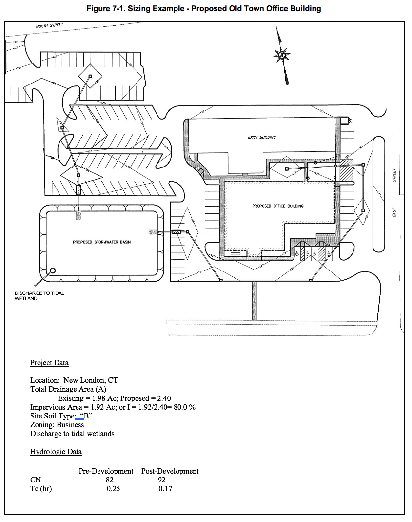
1.    Water Quality Volume

a.     Compute volumetric runoff coefficient, R

R = 0.05+0.009(I)

   = 0.05+0.009(80)

   0.77


b.     Compute water quality volume, WQV
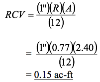
WQV = (1”)(R)(A)/12

          = (1”)(0.77)(2.40)/12

          = 0.15 ac-ft


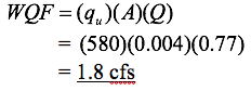
2.   Water Quality Flow


Compute the water quality flow (WQF) for off-line stormwater treatment.


a.     Compute the runoff depth, Q

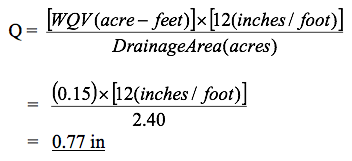
b.     Compute the NRCS Runoff Curve Number (CN)

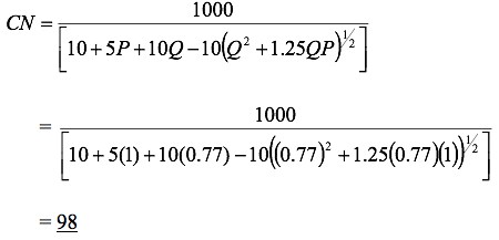
c.     Read initial abstraction, Ia                    (Table 4-1 in Chapter 4, TR-55)

Ia = 0.041

d.     Compute Ia/P

   = 0.041/1

   = 0.041

e.     Read initial abstraction, qu               (Exhibit 4-11 in Chapter 4, TR-55)

qu = 580 csm/in (Type III storm)

f.      Compute water quality flow (WQF)


3.    Groundwater Recharge Volume


Compute the groundwater recharge volume (GRV) using the hydrologic soil group approach.


a.     Read runoff depth to be recharged, D                                    (Table 7-4)

D = 0.25 in

b.     Compute net increase in site imperviousness, I (proposed) – I (existing)

I = 0.80-0.44

  = 0.36


c.     Compute groundwater recharge volume, GRV

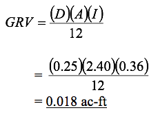
4.    Runoff Capture Volume


Compute the runoff capture volume (RCV) since the site discharges stormwater within 500 feet of tidal wetlands.


5.    Stream Channel Protection


Compute the required stream channel protection discharge using both “Two-Year Over-Control” methods recommended in Section 7.6.1.


a.     Method-1, control the 2-year, 24-hour post-development flow to 50% of the 2-year, 24-hour pre-development flow

Q2(control)    = (0.5) Q2(exist)

                 = (0.5)(2.2)

                 = 1.1 cfs

Q2(proposed)  = 0.9 cfs

Q2(proposed) < Q2(control), meets method-1 criteria

b.     Method-2, control the 2-year, 24-hour post-development flow to the 1-year, 24-hour pre-development flow

Q1(exist)    = 1.8 cfs

Q1(exist)    > Q2(prosed),  meets method-2 criteria


6.    Conveyance Protection


Site storm drainage conveyance system designed for a 10-yr, 24-hour post-development peak flow, Q10.


Q10  = 4.3 cfs


7.    Peak Runoff Attenuation

From TR-55 peak discharge summary worksheets:


Storm Event

Pre-Development (cfs)

Post Development (cfs)

10-year

4.3

4.0

25-year

5.3

5.2

100-year

6.8

9.8


8.    Emergency Outlet Sizing

Safe passage of the 100-year storm event under proposed conditions requires passing Q100 of 9.8 cfs through the proposed stormwater basin emergency spillway.  The spillway is designed to safely convey 9.8 cfs without causing a breach of the stormwater basin that would otherwise damage downstream areas or present a safety risk.

Summary of Sizing Requirements

Criterion

Requirement

Water Quality Volume

0.15 ac-ft

Water Quality Flow

1.8 cfs

Groundwater Recharge Volume

0.018 ac-ft

Runoff Capture Volume

0.15 ac-ft

Stream Channel Protection

0.9 cfs (2-year “over-control”)

Conveyance Protection

4.3 cfs (10-year)

Peak Runoff Attenuation

5.3 cfs (25-year)

Emergency Outlet Sizing

9.8 cfs (100-year)

References

Adams, T. 1998. Stormwater Facility Design: Calculating the First Flush. Pollution Engineering.


Brown, T. and D. Caraco. 2001. “Channel Protection”. Water Resources IMPACT.


Chang, G., Parish, J., and C. Sober. 1990. The First Flush of Runoff and Its Effect on Control Structure Design. Environmental Resource Management Division. City of Austin, Texas.


Claytor, R.A. and T. R. Schueler. 1996. Design of Stormwater Filtering Systems. Center for Watershed Protection. Silver Spring, Maryland.


Department of Commerce. 1961.Weather Bureau, TP-40.


Leopold, L.B. 1994. A View of A River. Harvard University Press. Cambridge, MA.


Leopold, L.B., Wolman, M.G., and J.P. Miller. 1964. Fluvial Processes in Geomorphology. W.H. Freeman and Company. San Francisco, CA.


MacRae, C. 1993. “An Alternative Design Approach for the Control of Instream Erosion Potential in Urbanizing Watersheds”. In Proceedings of Sixth International Conference on Urban Storm Drainage. Niagara Falls, Ontario.


MacRae, C. 1996. “Experience from Morphological Research on Canadian Streams: Is Control of the Two-Year Frequency Runoff Event the Best Basis for Stream Channel Protection?” In Effects of Watershed Development and Management on Aquatic Systems. L. Roesner editor. Proceedings of Engineering Foundation Conference. Snowbird, UT, August 4-9, 1996.


McCuen, R. and G. Moglen. 1988. “Multicriterion Stormwater Management Methods”. Journal of Water Resources Planning and Management. Vol. 114, No. 4.


New York State Department of Environmental Conservation (NYDEC). 2001. New York State Stormwater Management Design Manual. Prepared by Center for Watershed Protection. Albany, New York.


Novotny, V. 1995. Nonpoint Pollution and Urban Stormwater Management. Technomic Publishing Company, Inc. Lancaster, Pennsylvania.


Prisloe, M., Giannotti, L., and W. Sleavin, No date. “Determining Impervious Surfaces for Watershed Modeling Applications”. University of Connecticut, Cooperative Extension System. Nonpoint Education for Municipal Officials (NEMO) Project. Haddam, CT