4.2 Site Planning and Design Concepts
The concepts presented in this section are central to effective site planning and design for stormwater management and environmental resource protection. Each of these concepts is based on the fundamental objective of preserving a site’s natural hydrologic conditions. As discussed in Chapter Two, the hydrologic conditions and pollutant removal functions of a site can be altered significantly as a result of development. The traditional approach to site drainage has been to remove runoff from the site as quickly and efficiently as possible through the use of storm sewers and structural stormwater conveyances, and to provide detention facilities to manage increases in peak flows. This approach severely reduces the natural hydrologic and water quality functions of the site and contributes to the adverse environmental impacts discussed in Chapter Two.
A guiding principle of effective site planning is to preserve pre-development hydrologic conditions such as:
- Runoff volume and rate
- Groundwater recharge
- Stream baseflow
- Runoff water quality.
This can be accomplished through a number of techniques that should be integrated into the site planning and design process wherever possible. These techniques are described in the following sections of this chapter. In collaboration with DEP’s NPS Program, the University of Connecticut Cooperative Extension System’s Nonpoint Education for Municipal Officials (NEMO) Project offers assistance to Connecticut municipalities in implementing these site planning and design strategies. (See Additional Information Sources at the end of this chapter or visit http://www.nemo.uconn.edu).
Designing the Development to Fit the Terrain
Developments that are designed to “fit the terrain” of the site require significantly less grading and soil disturbance than those that are designed without regard for the existing topography. Road patterns should match the landform by placing roadways parallel to contour lines where possible. In doing so, natural drainageways can be constructed along street right-of-ways, thereby reducing the need for storm pipes. Open space development, allowable in many municipalities, can help preserve large natural areas and open space as well as make it possible to design around topographical constraints.
Limiting Land Disturbance Activities
Land disturbance activities such as clearing and grubbing, excavation, and grading result in erosion of exposed soils, increased sediment loadings, as well as increased volumes of runoff from a site. Limiting the land area disturbed by development can only be addressed comprehensively at the site planning level (Schueler, 1995). Land disturbance activities should be limited to only those areas absolutely necessary for construction purposes, in keeping with the natural features of the site, and should be clearly delineated in the field prior to construction. Land disturbance activities in proximity to wetlands, watercourses, steep slopes, and other sensitive resource areas should be avoided, or minimized if they cannot be avoided. Areas outside the disturbed zone should retain natural vegetation. This approach is more successful on larger lots where large areas of undeveloped land can be preserved. The successful application of this approach is more difficult and less practical on small lots in heavily developed areas (NJDEP, 2000).
Reducing or Disconnecting Impervious Areas
Reducing and disconnecting impervious surfaces are effective methods for preserving predevelopment hydrology. Reducing impervious coverage on a site directly limits the adverse impacts associated with impervious coverage. On a watershed basis, reductions in impervious coverage contribute directly to the ecological health of streams and receiving waters, as described in Chapter Two. Impervious surfaces that are not directly connected to the drainage collection system contribute less runoff and smaller pollutant loads than hydraulically connected impervious surfaces. Isolating impervious surfaces also promotes infiltration of stormwater runoff. Specific techniques for reducing or disconnecting impervious areas for road and lot development are described in Section 4.3, Alternative Site Design.
Preserving and Utilizing Natural Drainage Systems
The goal of traditional drainage design, to collect and convey stormwater runoff from the site as efficiently as possible, is in direct conflict with the objectives of water quality design, which is to slow down and attenuate runoff to allow filtration, infiltration, biological uptake, and settling of pollutants. Natural drainage features such as vegetated swales and channels and natural micro-pools or depressions should be preserved or incorporated into the design of a site to take advantage of their ability to infiltrate and attenuate flows and filter pollutants. The use of natural overland drainage features such as stabilized swales, where soil and hydraulic conditions allow, and the discharge of stormwater in a diffuse manner from level spreaders should be encouraged as an alternative to traditional storm sewer systems. Consistent with this approach is to design roads and parking areas at higher elevations in the landscape and locate existing swales along back lot lines within drainage easements (Pennsylvania Association of Conservation Districts et al., 1998). Natural low areas or depressions in the landscape should be preserved where possible to maintain infiltration of runoff in these areas similar to pre-development conditions.
Providing Setbacks and Vegetated Buffers
Setbacks and vegetated buffers provide protection of adjacent natural resources from areas of intensive development. A setback is the regulated area between the development and a protected area such as a wetland. A vegetated buffer is an area or strip of land in permanent undisturbed vegetation adjacent to a water body or other resource. Buffers protect resources from adjacent development during construction and after development by filtering pollutants in runoff, protecting water quality and temperature, providing wildlife habitat, screening structures and enhancing aesthetics, and providing access for recreation. Characteristics such as width, target vegetation, and allowable uses within buffers are managed to ensure that the goals designated for the buffer are achieved (Center for Watershed Protection, 1998b). Buffers along watercourses also serve to function as greenways that provide for connectivity of open space areas, allowing the movement of wildlife and the opportunity for passive recreation. The dual benefits that buffers provide for the protection of water quality from stormwater runoff and the creation of greenways are extremely important and complementary. Table 4-1 summarizes the benefits that can be achieved by buffer systems.
Table 4-1. Benefits of Watercourse Buffers
Benefit |
|
| Reduce nuisance drainage problems and complaints | Prevent disturbance of steeps slopes |
| Allow for lateral movement of streams | Mitigate stream warming |
| Provide flood control | Preserve important terrestrial habitat |
| Reduce stream bank erosion | Supply conservation corridors |
| Increase property values | Maintain essential habitat for amphibians |
| Enhance pollutant removal | Fewer barriers to fish migration |
| Provide opportunities for Greenways | Discourage excessive storm drain enclosures/channel hardening |
| Provide food and habitat for wildlife | Provide space for stormwater treatment practices |
| Protect associated wetlands | Allow for future restoration |
Source: Adapted from Center for Watershed Protection, 1998a.
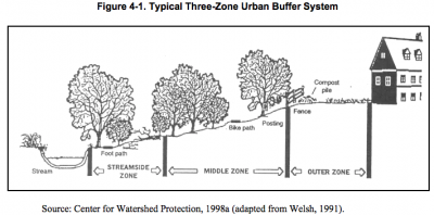 As a general rule, one hundred feet of undisturbed upland along a wetland boundary or on either side of a watercourse is recommended as a minimum buffer width depending on the slope and sensitivity of the wetland or watercourse. A conceptual three-zone stream buffer system designed for protecting aquatic resources while providing flexibility for development is shown in Figure 4-1 (Center for Watershed Protection, 1998a, adapted from Welsh, 1991). Each zone can have designated functions, width requirements, and management requirements.
Minimizing the Creation of Steep Slopes
Development or disturbance of steep slopes creates the potential for erosion and significant sediment loadings in the absence of effective stabilization measures. Development destroys vegetation, root systems, and soil structure (Pennsylvania Association of Conservation Districts et al., 1998). Although the definition of steep depends on soil characteristics and erodibility, slopes steeper than 10 percent, or even flatter slopes with highly erodible soils, typically require stabilization. The area and duration of disturbance on steep slopes should be minimized. Soil stabilization measures should be implemented in accordance with local erosion and sedimentation control ordinances, as well as the Connecticut Guidelines for Soil Erosion and Sediment Control (Connecticut Council on Soil and Water Conservation and the Connecticut Department of Environmental Protection, 2002).
Maintaining Pre-Development Vegetation
Pre-development vegetation should be maintained to the extent possible, especially on streambanks that might otherwise be cleared for view enhancement. Vegetation intercepts rainfall and promotes evapotranspiration, thereby reducing the volume of runoff from a site. In addition to providing erosion control, trees also provide shade to minimize thermal impacts to surface waterbodies. Trees and other vegetation can be incorporated into a site by planting additional native vegetation, clustering tree areas, and conserving existing native vegetation. Wherever practical, trees should be incorporated into community open space, street right-of-ways, parking lot islands, and other landscaped areas.
4.3.1 Streets and Parking Lots
These practices address the design of streets, parking lots, and other impervious surfaces associated with vehicular traffic in residential and commercial areas.
Reducing Street Widths
Many residential streets are wider than necessary. Reducing the width of streets can reduce impervious surfaces in a watershed. Other benefits of narrower streets include reduced clearing and grading impacts, reduced vehicle speeds (i.e., “traffic calming”), lower maintenance costs, and enhanced neighborhood character. Reducing or eliminating on-street parking can reduce road surfaces and overall site imperviousness by 25 to 30 percent (Sykes, 1989). In some areas, curbing can be eliminated to encourage sheet flow and facilitate the use of vegetated roadside swales. Eliminating curbing in residential and rural areas with nearby vernal pool habitat also allows amphibian migration across roads. An alternative to eliminating curbing is the use of Cape Cod curbing, which allows amphibians to climb.
Residential streets should be designed for the minimum required pavement width needed to support travel lanes, on-street parking, as well as emergency, maintenance, and service vehicle access. Residential street widths should be based on the following four variables (NEMO Technical Paper #9, Roads, Gibbons 1998a):
- Traffic Volume: A simple rule of thumb regarding traffic volume is the fewer the vehicles, the narrower the road may be. Many communities require a minimum width of 32 to 34 feet of pavement or two, adjacent 16- to 17-foot travel lanes for all roads. Research shows that 20-to 24-foot road widths (two 10- to 12-foot travel lanes) are adequate for most local roads.
- Design Speed: Slower design speeds allow for narrower road widths. Local residential roads should be designed to provide safe access to homes. Research indicates that as residential streets widen, accidents per mile per year increase exponentially and that the safest residential street width is 24 feet (Swift et al., 1998).
- Lot Width: As a general rule, large lots with long front yards require less on-street parking since large lots by their very nature have enough area to accommodate on-site parking. Roads serving large lots do not have to be designed with on-street parking lanes and therefore can be narrower.
- Parking Needs: The need for on-street parking is often used to justify wider residential streets. Roads designed to provide overflow parking from adjacent lots requires one or two additional parking lanes. However, not all roads are designed to accommodate on-street parking and therefore do not require additional parking lanes.
The standard 50- to 60-foot right-of-way width is recommended to provide adequate emergency access and parking. However, the paved portion of the right-of-way should be minimized to the extent possible. Table 4-3 presents minimum roadway width guidelines for residential subdivision street design.
Table 4-3. Minimum Residential Roadway Width Guidelines
| Terrain Classification1
|
Level | Rolling | Hilly | ||||||
| Development Density2
|
Low | Med |
High |
Low | Med | High | Low | Med | High |
| Right of Way Width (ft)
|
50 | 60 | 60 | 50 | 60 | 60 | 50 | 60 | 60 |
| Pavement Width (ft)
|
20-24 | 28 | 36 | 20-24 | 28 | 36 | 28 | 28 | 36 |
| Sidewalks and Bicycle Paths (ft) | 0 | 4 | 5 | 0 | 4 | 5 | 0 | 4 | 5 |
Source: Guidelines for Residential Subdivision Street Design, Institute of Transportation Engineers, Washington DC, 1993, in University of Connecticut, Transportation Institute, Technology Transfer Center Fact Sheet.
1Terrain Classification: Level – grade of 0% to 8%, Rolling – >8% to 15%, Hilly – >15%
2Development Density: Low – 2 or fewer dwelling units/acre, Med – >2 to 6 dwelling units/acre, High – more than 6 dwelling units/acre
Reducing Street Lengths through Alternative Street Layout
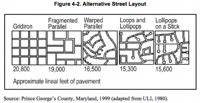 Street lengths and, therefore, total site imperviousness can be reduced through alternative street and subdivision layouts. Figure 4-2 illustrates how alternate layouts can reduce roadway impervious surfaces by up to 26 percent.
No single street layout is appropriate for all residential development. Roadway layout is highly dependent on site topography, density, traffic volume, and overall subdivision design. Residential areas with low traffic volume and minimal topographical relief have the most flexibility in design. In Connecticut, a majority of residential subdivisions use the “loops and lollipops” and “lollipops on a stick” configurations. These road layout designs utilize cul-de-sacs, loops, and short feed streets to accommodate the contours and natural features of a site. Open space development, a compact form of development that concentrates density on one portion of the site in exchange for reduced density elsewhere, also lends itself to reduced street lengths. Grid-based street layouts tend to have relatively longer overall street lengths. The exception is traditional neighborhood design, which incorporates community open space, a variety of housing types, and mixed land uses in a single project to emulate the characteristics of smaller, older communities (Center for Watershed Protection, 1998a).
Alternative Cul-de-sac Design
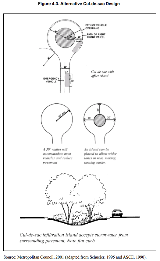 Cul-de-sacs have a large bulb located at the closed end of the street to enable emergency and service vehicles to turn around without having to back up. Traditional cul-de-sacs utilize a large-radius, paved turnaround that can dramatically increase the imperviousness of a residential subdivision. Alternatives to this traditional design include turnaround bulbs with smaller radii and the use of a landscaped island (i.e., rain garden or bioretention area) in the center of the cul-de-sac to collect rainwater from the end of the roadway.
Reducing the radius of a typical cul-de-sac turnaround from 40 to 30 feet can reduce impervious coverage by nearly 50 percent (Schueler, 1995). A 30-foot radius will accommodate most vehicles and reduce pavement. Cul-de-sac bioretention islands have been used successfully in various parts of the country, including a demonstration subdivision in Waterford, Connecticut. These islands can be landscaped with low maintenance perennials or shrubs appropriate for the soil and moisture conditions. Bioretention and rain gardens are discussed later in this chapter. If a cul-de-sac island is used, the cul-de-sac radius should allow for a minimum 20-foot wide road. To make turning easier, the pavement at the rear center of the island may be wider (Metropolitan Council, 2001). Figure 4-3 illustrates these cul-de-sac design concepts.
Reducing the Use of Storm Sewers
The use of swales and other vegetated open channels should be encouraged in residential streets, parking lots, and back yards in place of conventional storm drain systems. Open vegetated channels provide the potential for infiltration and filtering runoff from impervious surfaces, as well as groundwater recharge and reduced runoff volume. In addition to the water quality benefits that open vegetated channels provide, these systems are also significantly less expensive to construct than conventional storm drain systems. The use of vegetated drainage swales in lieu of conventional storm sewers may be limited by soils, slope, and development density. In many cases, subdivision ordinances discourage or prohibit the use of open vegetated channels for roadside drainage due to concerns over inadequate drainage, maintenance issues, pavement stability, and nuisance insects (if water is allowed to stand for longer than 7 to 10 days). This practice requires educating local citizens and public works officials who expect runoff to disappear quickly after a rainfall event (Pennsylvania Association of Conservation Districts et al., 1998).
Reducing Parking Lot Size
Parking lots are the largest component of impervious cover in most commercial and industrial land uses (Center for Watershed Protection, 1998a). The number of parking spaces at a site is determined by local parking ratios which dictate the minimum number of spaces per square foot of building, dwelling units, persons, or similar measure. Parking ratios are typically set as minimums, not maximums, thereby allowing for excess parking. In addition, local parking codes often require standard parking stall dimensions to accommodate larger vehicles. A recent parking study conducted for the Northwestern Connecticut Council of Governments and Litchfield Hills Council of Elected Officials demonstrated that, in most cases, demand for parking is less than what is required by zoning, while more parking than required by zoning is provided. Big box retail parking lots typically have more excess parking than for any other land use (Draft Northwest Connecticut Parking Study, Fitzgerald & Halliday, Inc. 2002).
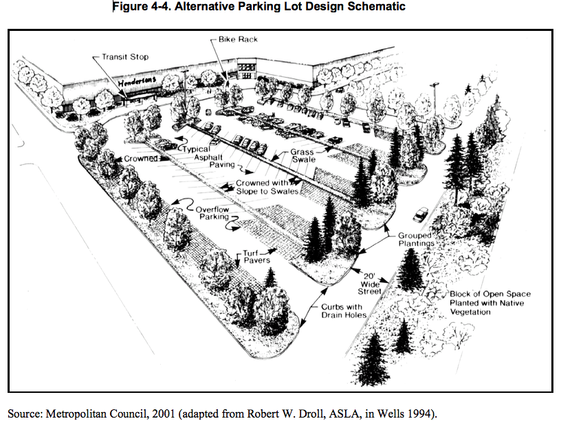 Reducing minimum parking requirements, establishing or enforcing maximum parking lot ratios, reducing parking stall size, and incorporating alternative internal geometry or traffic patterns through the use of one-way aisles and angled parking stalls can reduce parking lot size and impervious cover. Parking demand ratios should be based upon site-specific parking generation studies, where feasible (Metropolitan Council, 2001). Incorporation of bioretention facilities or other stormwater treatment devices (i.e., sand filters, vegetated swales, filter strips) into parking lot design features such as perimeter and median strips can further reduce pollutant loads from these areas. Figure 4-4 is a schematic of an alternative parking lot design.
Shared parking is a similar strategy that reduces the number of parking spaces needed by allowing adjacent land uses to share parking lots. For shared parking to operate successfully, the participating facilities should be in close proximity to each other and have peak parking demands that occur at different times during the day or week (Center for Watershed Protection, 1998a). Examples of facilities with different daily peak hours and potential candidates for shared parking include professional offices, banks, and retail stores (daytime peak hours) and theaters, restaurants, and bars (evening peak hours). Use of phantom parking is also recommended. Under a phantom parking strategy, sufficient land is reserved for projected parking requirements, but only a portion of the parking area is constructed at the outset. Additional areas are paved on an as-needed basis.
Using Permeable Paving Materials
Permeable paving materials are alternatives to conventional pavement surfaces designed to increase infiltration and reduce stormwater runoff and pollutant loads. Alternative materials include modular concrete paving blocks, modular concrete or plastic lattice, cast-in-place concrete grids, and soil enhancement technologies. These practices increase a site’s load bearing capacity and allow grass growth and infiltration (Metropolitan Council, 2001). Stone, gravel, and other low-tech materials can also be used as alternatives for low traffic applications such as driveways, haul roads, and access roads.
Porous asphalt or concrete, also known as porous pavement, is similar to conventional asphalt but formulated to have more void space for greater water passage through the material. Traditionally, porous pavement has had limited application in cold climates such as Connecticut due to the potential for clogging as a result of sand application. Porous pavement has been successfully used for some parking lot applications in New England where the underlying soils are sufficiently permeable. One example is a parking lot demonstration project at Walden Pond State Reservation in eastern Massachusetts.
While permeable paving materials can make sense in many parking lot designs, site-specific factors such as accessibility, soils, maintenance, and long-term performance must be carefully considered. Permeable paving materials are most appropriate in areas of low traffic volume (e.g., generally less than 500 average daily trips or ADT) such as roadside rights-of-ways, emergency access lanes, delivery access routes, residential driveways, and overflow parking. Chapter Eleven of this manual contains additional siting and design guidance for permeable pavement materials.
4.4.2 Bioretention/Rain Gardens
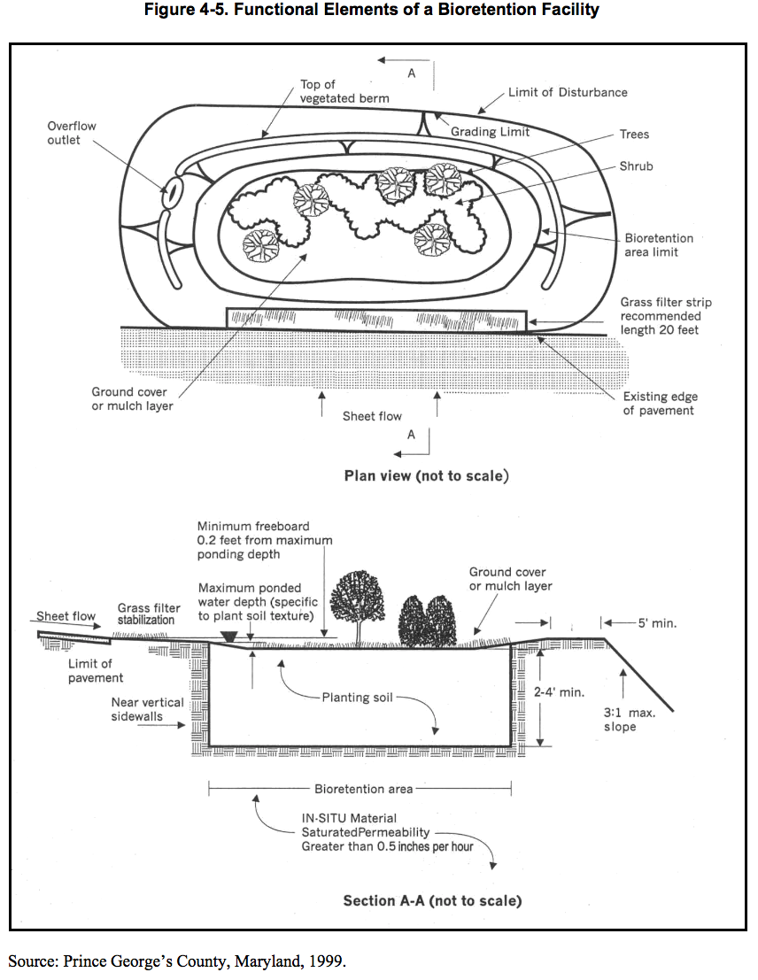 Bioretention is a practice to manage and treat stormwater runoff by using a specially designed planting soil bed and planting materials to filter runoff stored in a shallow depression (Prince George’s County, Maryland, 1999). Bioretention areas are composed of a mix of functional elements each designed to perform different functions in the removal of pollutants and attenuation of stormwater runoff. Bioretention removes stormwater pollutants through physical and biological processes, including adsorption, filtration, plant uptake, microbial activity, decomposition, sedimentation, and volatilization (U.S. EPA, 2000). The major components of a bioretention system include:
- Pretreatment area (optional)
- Ponding area
- Ground cover layer
- Planting soil
- In-situ soil
- Plant material
- Inlet and outlet controls.
Figure 4-5 is a schematic of a typical bioretention facility depicting each of these functional elements. Bioretention facilities are most effective if they receive runoff as close as possible to the source and are incorporated throughout the site (Pennsylvania Association of Conservation Districts et al., 1998).
Rain gardens are a small-scale form of bioretention that can be incorporated into a variety of areas in new and existing developments, including:
- Residential yards
- Street median strips
- Road shoulder rights-of-way
- Parking lot islands
- Under roof downspouts.
Rain gardens serve as a functional landscape element, combining shrubs, grasses, and flowering perennials in depressions that allow water to pool for only a few days after a rain (Metropolitan Council, 2001). The soil absorbs and stores the rainwater and nourishes the garden vegetation. Rain gardens are an effective, low-cost method for reducing runoff volume, recharging groundwater, and removing pollutants. Figure 4-6 shows examples of several rain garden designs for residential lots.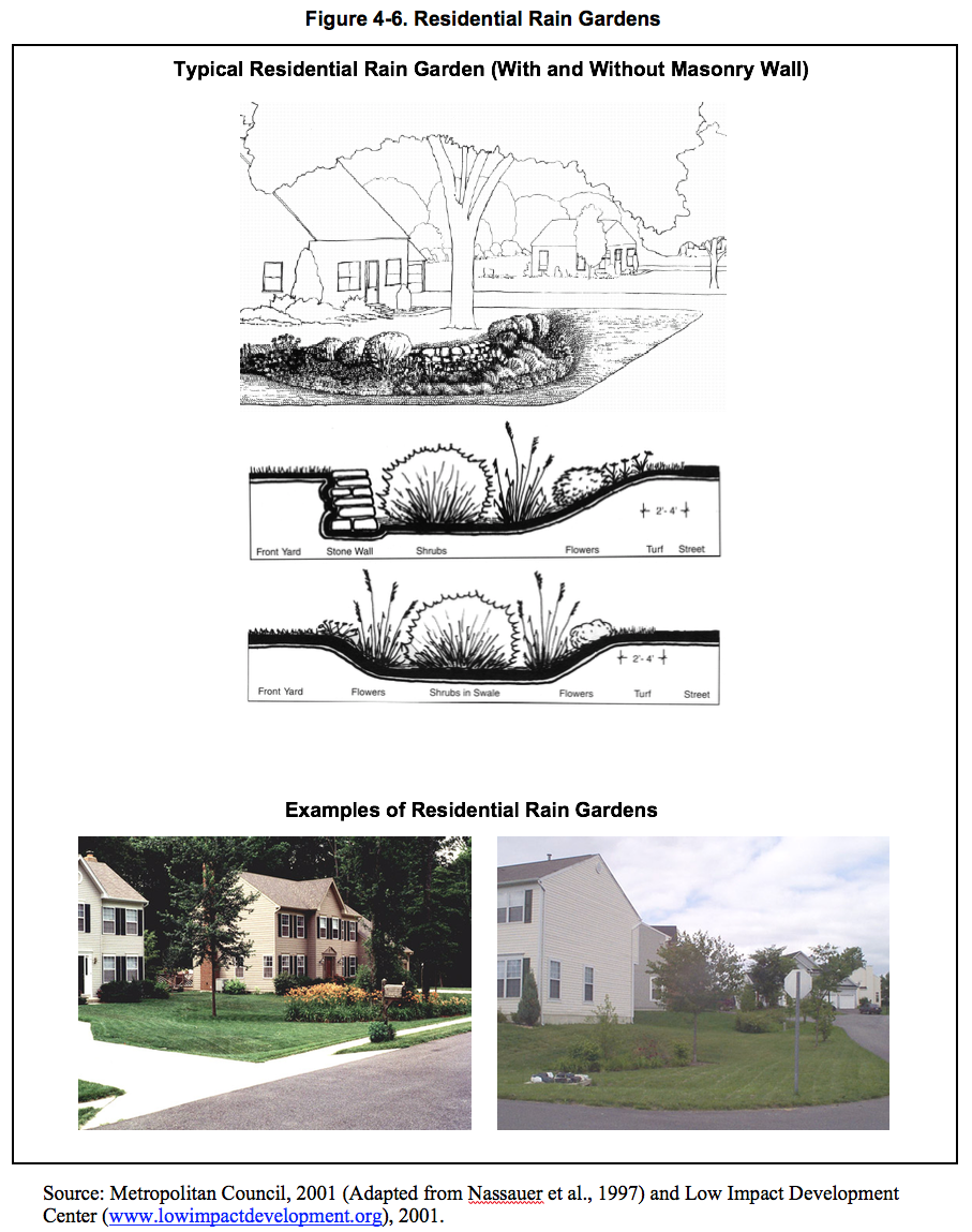
4.4.3 Dry Wells/Leaching Trenches
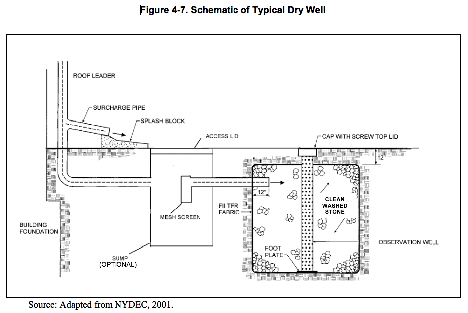 Dry wells are small excavated pits or trenches filled with aggregate which receive clean stormwater runoff primarily from building rooftops. Dry wells function as infiltration systems to reduce the quantity of runoff from a site. Dry wells treat stormwater runoff through soil infiltration, adsorption, trapping, filtering, and bacterial degradation (Prince George’s County, Maryland, 1999). Figure 4-7 shows a schematic of a typical dry well. The use of dry wells is applicable for small drainage areas with low sediment or pollutant loadings and where soils are sufficiently permeable to allow reasonable rates of infiltration and the groundwater table is low enough to allow infiltration. Chapter Eleven contains additional design guidance for dry wells.
4.4.4 Rainwater Harvesting
Rain is a renewable resource and is abundant in Connecticut. Rainwater harvesting can be used to supply water for drinking, washing, irrigation, and landscaping. It generally involves five main components - catchment, conveyance, purification, storage, and distribution. Catchment areas are most commonly roofs, while conveyance is via gutters and roof leaders. Rainwater is stored in either rain barrels or cisterns (water tanks). Purification for reuses other than drinking and washing primarily involves directing the initial flow of runoff, which contains the highest levels of accumulated contaminants, away from the storage system. Finally, distribution is through garden hoses or typical plumbing, depending on the application.
For the purposes of this manual, rainwater harvesting can be used to retain a portion of stormwater runoff during rain events and release it during dry periods such that the total volume of runoff is reduced. However, there are additional benefits to harvesting rainwater. Rainwater is generally very soft compared to other sources as it does not come in contact with soil and, therefore, contains low levels of dissolved salts and minerals. This makes it preferable for irrigation, gardening, and landscaping. If used for drinking and washing, soft water is less taxing on plumbing and water tanks.
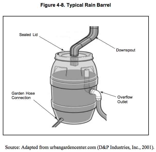 Rain barrels are designed to retain small volumes of runoff for reuse for gardening and landscaping. Rain barrels are applicable to residential, commercial, and industrial sites and can be incorporated into a site’s landscaping plan. Multiple rain barrels can be used to retain larger volumes of runoff. The size of the rain barrel is a function of rooftop surface area and the design storm to be stored. For example, one 42-gallon rain barrel provides 0.5 inch of runoff storage for a rooftop area of approximately 133 square feet (Prince George’s County, Maryland, 1999). Figure 4-8 shows a typical rain barrel.
Cisterns store larger quantities of rooftop stormwater runoff and may be located above or below ground. Cisterns can also be used on residential, commercial, and industrial sites. Pre-manufactured cisterns come in a variety of sizes from 100 to 10,000 gallons. However, even larger concrete cisterns may be constructed in place for large industrial, commercial, and public uses.
From a stormwater management perspective, the use of cisterns for commercial development where proposals include high levels of impervious cover, particularly in highly urbanized areas, should become a more commonly implemented stormwater management practice in the future.
General design considerations for rain barrels and cisterns include:
- Equip rain barrels with a drain spigot with a garden hose threading.
- Use a tight-fitting, light-blocking lid to keep children and animals out of the water, stop the development of algae, and limit access to standing water by mosquitoes and other nuisance insects. Alternatively, a small mesh screen could be used over the hole in the barrel/cistern to limit mosquito-breeding potential.
- Use a roof washer (collection and disposal of the first flush of water from a roof) to catch accumulated debris and divert the first flush of runoff away from rain barrels or cisterns.
- Use an overflow device to direct excess water away from a building’s foundation when the tank is full.
- Monitor cistern intakes and overflows for blockage.
- Locate cisterns as close to supply and demand as possible.
- Size storage volume based on seasonal rainfall data and anticipated water requirements.
- For drinking water supply, purification using ultraviolet light, ozonation, chlorination, reverse osmosis, and carbon filters can be used.
4.4.5 Vegetated Roof Covers
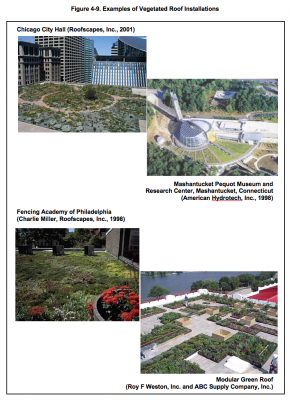 Vegetated roof covers, also referred to as “green roofs”, are layers of vegetation installed on building rooftops. Green roofs are an effective means for reducing urban stormwater runoff by replacing impermeable rooftops with permeable, vegetated surfaces. Rainwater is either intercepted by vegetation and evaporated to the atmosphere or retained in the substrate before being returned to the atmosphere through transpiration and evaporation. Several examples of vegetated roof installations are shown in Figure 4-9.
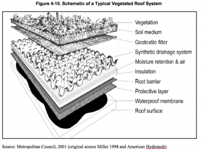 The green roof is a multilayered, constructed roof system consisting of a vegetative layer, media, a geotextile layer, and a synthetic drain layer. Green roofs have been used extensively in Europe and are becoming more common in the United States. A variety of green roof designs exist. The simplest consists of a light system of drainage and filtering components and a thin soil layer, which is installed and planted with drought-resistant herbaceous vegetation (Metropolitan Council, 2001). This type of system is called an extensive system. More complex green roof systems such as roof gardens built to accommodate trees, shrubs, and recreational access are called intensive systems. Figure 4-10 is a schematic of the functional components of the simpler extensive vegetated roof system.
Recently developed, modular green roof systems are available for new installations and building retrofits. These systems consist of interlocking modules containing plants that are shipped to the roof site for installation. The modules can be removed or replaced, thereby facilitating roof maintenance and repair. An example of a modular green roof system is shown in Figure 4-9.
Green roofs are effective in reducing total runoff volume. For example, simple vegetated roof covers, with approximately 3 inches of substrate can reduce annual runoff by more than 50 percent in temperate climates (U.S. EPA, 2000). Green roofs not only retain rainwater, but also moderate the temperature of the water and act as natural filters for any of the water that happens to runoff (Green Roofs for Healthy Cities Website, 2001). Green roofs in urban areas offer a variety of other benefits such as:
- Reduced energy costs by providing building insulation
- Conservation of land that would otherwise be required for stormwater controls
- Improvement of air quality by reducing carbon dioxide levels and binding airborne particulates
- Air temperature regulation and reduction of the “urban heat island” effect
- Sound insulation
- Improved aesthetics and views from other buildings
- Habitat for birds.
Design considerations for vegetated roof covers include structural and load-bearing capacity, plant selection, waterproofing and drainage, and water storage (Metropolitan Council, 2001). Limitations of green roof systems include:
- Damage to waterproofing materials may result in serious roof damage
- Can be expensive to design and construct
- Sloped-roof applications require additional erosion control measures
- Higher maintenance than conventional roof.